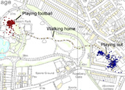
A bit I ran across this morning: Tracking Capable Kids, a project on the Children’s Activities, Perception and Behaviour in the Local Environment from UCL’s Centre for Transport Studies (CTS), supported by CASA, the Bartlett School of Planning, and the Department of Psychology.
"the project focused on monitoring the energy expended and the patterns of travel of children between home and school focuses on understanding how and why children walk and play in an activity context. (...) We sampled some 180 children aged between 8 and 10 in three Hertfordshire primary schools over a four day period using a variety of equipment and questionnairiaes to establish their activity patterns. GPS monitors on the kid’s wrists and RTS energy monitors around their waists record movements. The kids filled in diaries and produced mental maps of their environment during the four day period in question (...) A fascinating array of data has been generated and the project team is working on analysing this information at many scales and relating this to the social economic order characteristic of the households of which the children are a part."


Why do I blog this? some interesting bits here, need to read the papers about it. Besides, the question "How children play in their local environment?" is very relevant to my own research about mobile gaming and spatial practices.